Monday, August 14, 2017

Last Stop, Saint John's Newfoundland

Well, we're back in the USA after a very nice 3 weeks on the rugged and beautiful island of Newfoundland.  We're currently in Maine, headed for Vermont, to stay in the cool for a few days while we figure out our next move.

After Twillingate, we stayed with Loretta's first cousin Philamina (Phil) and her husband Jerome.  They live on a pond outside the provincial capital city of Saint John's with plenty of room for a couple motorhomes to invade.  Some people are so courteous like that, having homes where we can park for free.  We stayed a few nights and had a good visit, including a trip into the city to see the sites.  Fred got a call from the medical folks and his turn came for an appointment all the way back in Corner Brook, so they left on Monday, while we hit the ferry on Thursday.  We stayed a few nights at a cliffside campground called the Celtic Rendezvous on the east coast.  It was very scenic and relaxing, with humpbacks playing in the cove right below the campsite.

Jerome took me cod fishing near the house.  We caught a few, and saw some bald eagles to boot.

Lakefront parking for two, please.

Our rig and the flag of Newfoundland and Labrador alongside the Canadian flag.  I think we see more Canadian flags at people's homes than US flags back in the States.

The group, Fred and Loretta at left and Phil and Jerome at right.

Laurie coming back in from the deck "oooh Phil, what a lovely table!"

We actually got a window in our cabin for the overnight journey from Saint John's (Argentia, technically) back to Port aux Basque, where we crossed over into Newfoundland.  It's a lot further from the east coast.

Intrepid travelers at Signal Hill, overlooking the Saint John's narrows leading into the harbor.

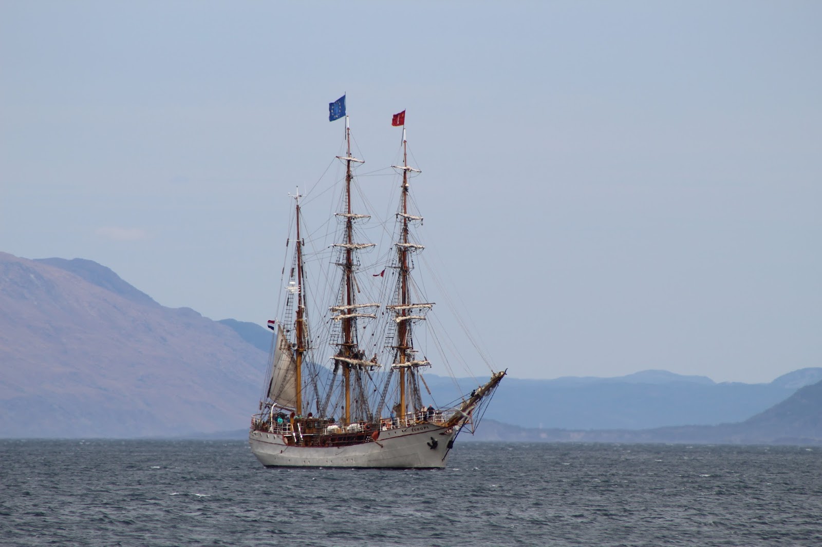
This was a pretty lucky shot.  At first glance, this just looks like a normal sailboat with 2 masts, just a normal ketch coming back in from a day sail, right?  It's actually a 186 foot long mega yacht called the Mondango III.  If you zoom in, you can see tiny people on the deck.  For a mere $200,000 a week, you can charter her for a cruise.  Room for 5 couples, so split 5 ways that's only $40K a week.  What a bargain!

Our view from Celtic Rendezvous

Whales playing all over the place

Really hard to get a clear tail fluke shot

That's a good dog.  Missy would jump in and try to catch a whale.

Saturday, August 12, 2017

Twillingate

After the west coast, we headed east on the Trans Canada Highway (TCH) toward Saint John's.  We stopped for a couple nights just past Gander to see the small town of Twillingate and its associated islands and lighthouses.  It's a really pretty area and we had wonderful weather for sight seeing.  One of Twillingate's big attractions is iceberg tours earlier in the year.  They break off from the Greenland ice sheet and wash up on Newfoundland's northern shore every spring.  By August, they were virtually all melted.  We saw one grounded across the bay using binoculars, but too far away to appreciate.  No commentary on the pictures, just really pretty coastal scenery from northern Newfoundland on a warm, sunny day in August!


Sunday, August 6, 2017

Western Peninsula, Newfoundland

The west coast of Newfoundland is really rugged and remote, but very beautiful.  We only made it as far north as Port aux Chois, for those following on the Don and Laurie's Travels interactive map and guide.  While on the coast, Fred took us around his home town of Corner Brook, a pretty large port city for Newfoundland, with all the comforts of home.  Especially hills.  Lots of hills.  We stayed two nights in the city park before moving up north.  The tall ships were making their way into Corner Brook for the weekend, so I got a couple nice pictures.  After Corner Brook, we went up north a bit, staying north of Cow Head, then back down for a lovely evening cliff side in Parson's Pond before arriving in Rocky Harbour to tour Gros Morne National Park.  Here are some pictures:

Loretta, Fred and me.  Laurie wasn't feeling well, so she passed on a beautiful, but chilly boat tour in Corner Brook.  There were two gents playing traditional Irish and Newfoundland folk music in the cabin below, but it was such a lovely evening everybody was up on the top deck.

Yeah Canada!

We don't get nice clear skies for sunset pictures every day.

The lumber mill in Corner Brook, lots of raw material in the yard.

One of 4 we saw making their way up river to Corner Brook.

Nice right?  Like something out of a pirate movie.  If you zoom in, you can see people working the square sail in the foremast.

Corner Brook from Captain Cook's point.  I didn't realize he mapped Newfoundland before heading out to the Pacific.  The Cook Islands are named for him, and he was killed in Hawaii.

Town from the boat, headed out to see the sea
Arches Provincial Park, these were carved by the sea

Missy is getting really adventurous.  She didn't mind scampering over all these big smooth rocks.  I would have thought it would hurt her feet.  She doesn't like sea water though, so she learned it doesn't taste so good...

The rain socked us in at Port aux Chois, but still got a lighthouse photo

Our cliff side camp spot in Parson's Pond

What a view, sunset was awesome

Nice, eh?

We took a boat tour in Gros Morne National Park, in Western Brook Pond.  Pretty big lake actually, use to be a river leading to the sea but the stream got cut off and it filled in with fresh water over the eons.

Interesting how this tree must have gotten started, all alone and exposed on top of this rock, but it showed the rock who's boss!

One of many waterfalls in Western Brook Pond

Wet, intrepid travelers.  The weather for our Gros Morne boat tour was a little...gross.

Western Brook Pond is about 400 feet deep.  I was watching the depth sounder, and right off one of these cliffs it was still over 100 feet deep.

The gray weather had a beauty all its own

End of the line, where Western Brook feeds into the pond.  They'll drop you off at the dock for hiking if you have a back country pass.  Way back...


Monday, July 31, 2017

Picadilly, Newfoundland

Just a short 7 hour ferry ride from the northern tip of Nova Scotia, we arrived at our northern destination, Newfoundland!  Coming off the ferry, it was dark and foggy, the marine layer was thick and rolling over the mountains like some kinda Lord of the Rings movie.  Our friends Fred and Loretta Welsh met us on the highway about an hour off the boat to lead us into their friendly little town of Piccadilly.  On the map of Newfoundland, look for the town of Stephenville on the southwest corner, site of the former Harmon Air Force Base.  We were running around the peninsula west of town.  Interesting geographical note, when you're driving across the isthmus, the water on the north side is held back by a levy, and it's a few feet higher than the water on the south side, though yes, both at "sea level."  The road is actually below the level of the sea on the north side.  Saw it with my own 2 eyes.

We met the Welshes at the Hanscom AFB campground outside of Boston in 2012.  Fred retired the next year and they started snowbirding to Florida every winter.  I blogged about them and their friends Danny and Marlene back in April when the 6 of us took a cruise together.  Danny owns a construction company, a restaurant, and is building a campground.  That's where we stayed in Picadilly.  Here are some pictures of our first week in Newfoundland:

Sitting in the parking lot at the ferry terminal in North Sydney, Nova Scotia, waiting for our turn to load up. 

About to drive into the belly of the ship.  There are 3 car decks, this thing is huge.  The iron works at the top of the picture are the car loading gangway for the deck above the one I'm parking on.

We made it!  That's our rig to the left of the sign.  We disconnected to load into the ferry.  They say it's cheaper, and in Alaska we had to do some backing up to get parked straight.  We can't back up with the car attached.

Butte du Cap on a very calm day.

Beautiful, rugged and sparsely populated.  Newfoundland.

Okay, so my Dad taught me to measure twice and cut once.  We were driving along and Fred pointed out this fellow who built a garage and didn't measure twice for the roof line where it approaches a telephone pole.  Oh well, just cut ahnudder two or tree feet outa dare and she's good...

The front gate of the former Harmon AFB.  The runway is still in use for commercial flights, and all the buildings are pretty much intact, though turned over for civilian use.

Missy is about fully grown now, 8 months old in this picture.

Danny at frame left, Fred concentrating on a bite of lobster and Marlene.

Fresh steamed lobster heads.  We ate the claws and tails.  If you called heads, you win!

Thursday, July 20, 2017

Nova Scotia

After PEI, we headed into Nova Scotia where we stayed in 4 different places, all on the water.  On the way into Nova Scotia, we stopped for fuel on the outskirts of a little town called Springhill.  Fred, the fellow we're going to see in Newfoundland, was a town constable there until 2012.  I asked the woman behind the counter if she'd lived there long, yes, and do you know a retired constable named Fred Welsh.  "Oh, you missed him my dear, he moved back to Newfoundland!"  Small world.  I talk to one person in Springhill and sure enough, she knows Fred.  Our first stop was in a Town called Truro.  It's at the very end of the Bay of Fundy, where the tides are so strong.  The rising tide pushes a small wave called a bore up the Salmon River, and it looked like a good place to see central Nova Scotia.  We took a few nice country drives and went for a really beautiful walk with Missy in the city park.  Three nights and we're outa there.

Next stop was land's end on the southwest coast, Yarmouth.  There's not much in Yarmouth at all, but we had a beautiful camping spot with a fire ring.  It seemed like we had the place all to ourselves, Castle Lake Campground and Cabins.  It's pretty new, so still some road work and such going on.  We found a manicured 1/2 mile path going down to the ocean, so of course Missy got a lot of exercise.  Three nights, and we're outa there.  Next top: Halifax.

Halifax is the provincial capital, and a pretty good sized metropolitan area.  We stayed at a park called Woodhaven, not too bad, but we spent most of our time running around the countryside seeing the sights.  There's a touristy place about an hour outside of town called "Peggy's Cove."  We had to stop there, otherwise we'd never be able to face our friend Peggy again.  It's just a lighthouse and interesting rock formations, but it made for a nice drive in the country.  Time flies though, and after a couple trips to the downtown waterfront, it was time to move on.  Four nights and we're outa there.  Next stop: Cape Breton Island.

The northern third of Nova Scotia is an island attached to the rest via a causeway and bridge, not much at all separates them though.  This is one of those "we need to come back" areas.  We spent 3 nights at the northern tip waiting on the ferry to Newfoundland.  It's beautiful, with the Bras d'or Lakes pretty much everywhere you turn.  They're like an interconnect inland sea of large saltwater bays, but they call them lakes because they're so protected.  Really pretty.  We intend to stop for a few more days in a different area of Cape Breton Island when we get back from Newfoundland, 3 weeks from today.  We get on the ferry in a few hours.  Here are some Nova Scotia pictures:

Maybe it's called a tidal "bore" for a reason.  You have to be here, pictures aren't clear enough to see the wave coming.  This is low tide.

Same spot a few minutes after the tide starts rising.  Hard to see it in the pictures, but this is the bore coming in, the tide rises about a foot a minute.  These folks are on a zodiac raft trip up the river at high tide.


This is the bulk barn.  Everything from candy to dried rice, beans, flour of all sorts, spices, all available "by the pinch or by the pound."  They had pretty much everything you can scoop or spoon into a bag or container.  Everything's sold by weight, even shortening and pie filling.

Our spot at Castle Lake campground.  They're not always this secluded.

The actual cove..Peggy's Cove.  It's tiny.

Peggy's Cove Lighthouse and the marked up boulders left over when the last glacier retreated.

Intrepid travelers.  I told the fellow to get the whole lighthouse.  Sigh.

Hey Peggy, nice cove!

Driving around Cape Breton Island, Google Maps didn't tell us there was a $7 ferry crossing.  Cool!

Bras d'or Lake.  Pronounced "broader lake"

The view from our roof and windshield while waiting for the ferry to Newfoundland at Arm of Gold campground.  We had an unobstructed 180 degree view of the water.  This is a panorama, so it's a little hard to make out.